Guidelines for the production of these maps were drawn up, but these were generally ignored. Nevertheless, dwelling houses are generally coloured red, other buildings black, while trees are usually drawn to indicate woodland and water features are coloured blue. Roads are generally coloured pale yellow and are included, along with such features as canals, even when not subject to tithe.
Introduction
The terrace of canal worker's cottages just south of Preston Brook Bridge on the Bridgewater Canal may appear typical of the type and doesn't justify any particular research, but as the Bridgewater Canal, opened in 1760, is often claimed to be the construction that kick-started the Industrial Revolution, with the extension to Preston Brook being built just 15 years later these may be some of the earliest workers cottages built in the industrial age.
This article records some of features of the site that make it of interest including the building itself, other nearby properties built by the Bridgewater Canal Company, house numbering and the area to the rear of the cottages
You'll find I often refer to the Bridgewater Canal Company, but this is a simplification as companies were a mid-nineteenth century invention. Following the death, in 1803, of the third Duke of Bridgewater, who built the canal, it was his trustees that operated the canal. More recently the Manchester Ship Canal Company ran the canal and currently it is Peel L&P that control the canal through a subsidiary the Bridgewater Canal Company Limited.
The Cottages Today
We start with what the casual observer will see if walking along the A56 through Preston Brook and then along the towpath in front of the cottages.
 The view, looking south, from the A56 as you pass over Preston Brook
Bridge. You can only see the end of the terrace that forms
"Canalside Cottages".
The view, looking south, from the A56 as you pass over Preston Brook
Bridge. You can only see the end of the terrace that forms
"Canalside Cottages".
 © Google
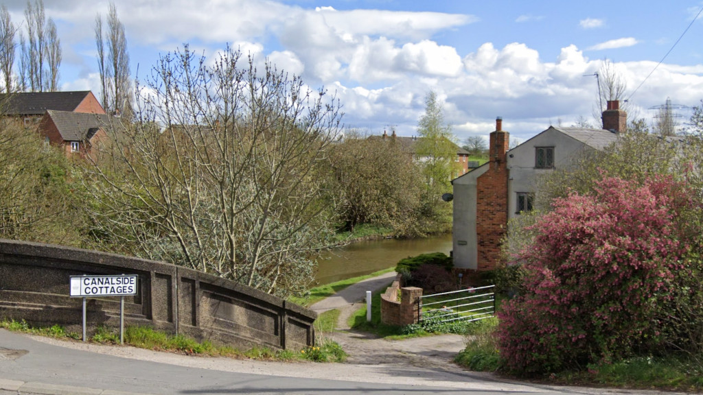
The view down the steep cobbled ramp off the A56 bridge to
cottages that face east across the tow path.
© Google
The view down the steep cobbled ramp off the A56 bridge to
cottages that face east across the tow path.
 © Bridgfords Estate Agents
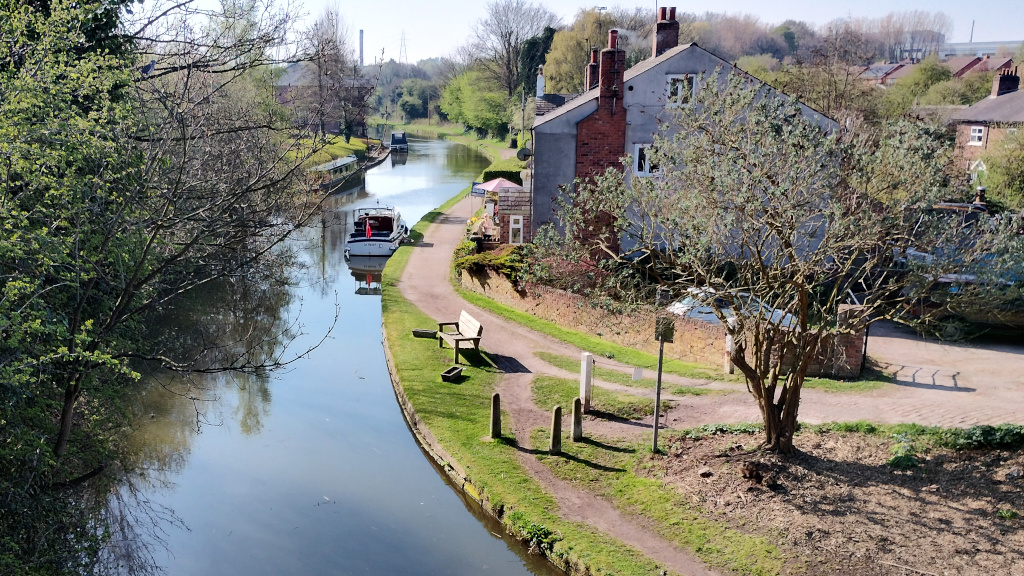
Taken from a drone, this is the view after walking a few yards
further along the A56 until you reach the railway bridge over
the west coast main line to Glasgow and then lift yourself 50ft into
the air.
© Bridgfords Estate Agents
Taken from a drone, this is the view after walking a few yards
further along the A56 until you reach the railway bridge over
the west coast main line to Glasgow and then lift yourself 50ft into
the air.
© Google The terrace as seen from the towpath, taken in September 2023 by a contributor to Google Maps. You can drag on the image to zoom in and out and rotate the view.
Ownership History
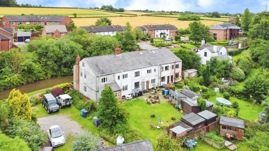
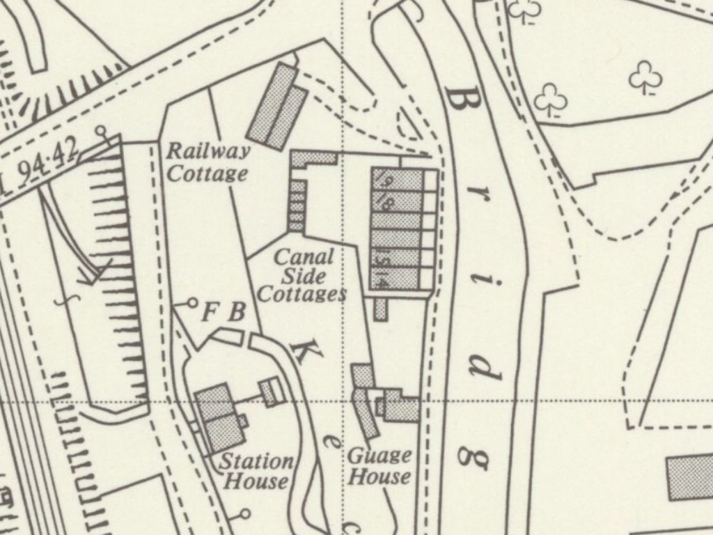
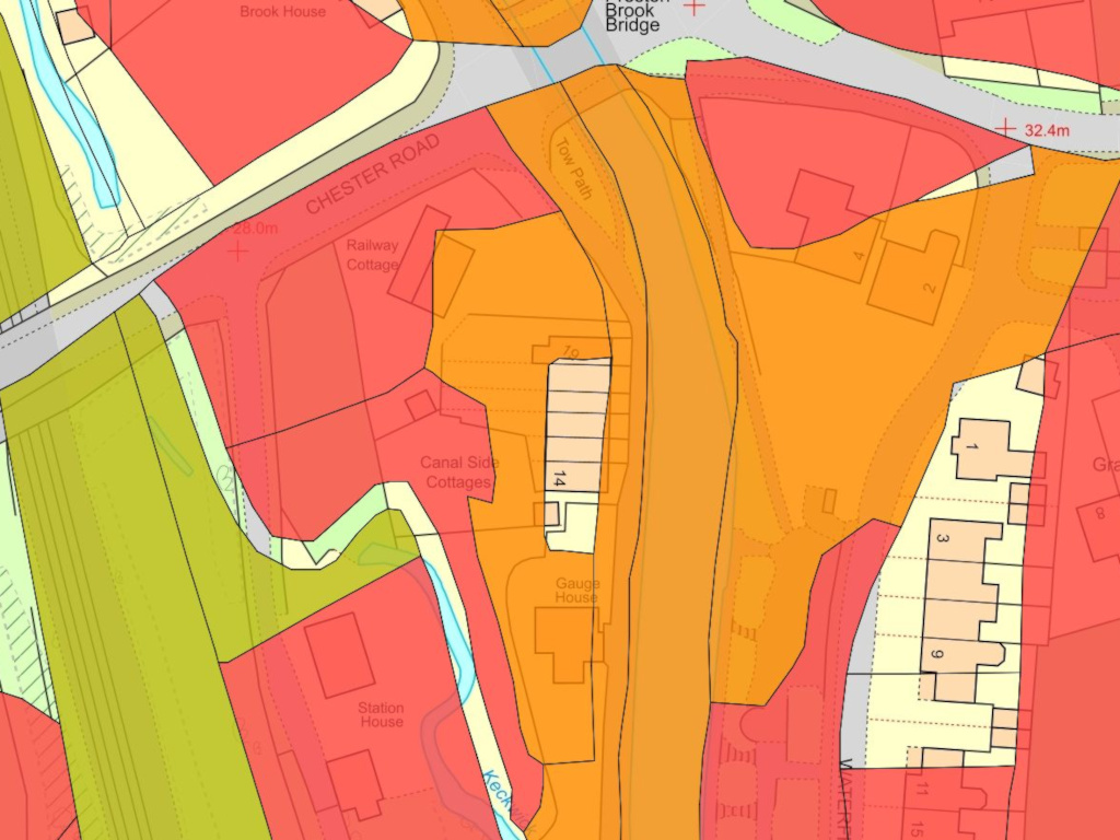
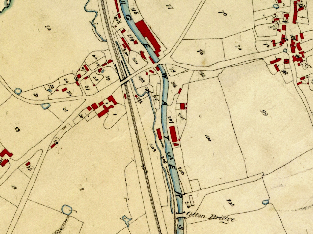
What you see in the aerial picture above requires a little interpretation and is probably best explained together with the Ordnance Survey map from 1963 seen below. There you see the six cottages, numbered 14-19. These each have a small front garden of their own and behind them a communal area that includes a cluster of small buildings, presumably individual toilets built as far from the cottages as possible. To the south of the cottages is the mis-spelled "Guage House" and this has garden areas north and south of it.
As we will see, west of the canal, it is only this land together with the towpath, that belonged to the Bridgewater Canal Company in the period when the cottages were built. The remainder of the land east of the railway line was owned by Thomas Brock Yates who owned virtually everything around Preston on the Hill.
 Source:
National Library of Scotland
This Ordnance Survey map from 1963 shows the communal
land with the toilets clustered in a group at the furthest point from
the dwellings. To the south is the mis-spelled "Guage House"
which has garden areas to its north and south.
Source:
National Library of Scotland
This Ordnance Survey map from 1963 shows the communal
land with the toilets clustered in a group at the furthest point from
the dwellings. To the south is the mis-spelled "Guage House"
which has garden areas to its north and south.
This means the area to the left of the picture, where you see parked cars and the area in the foreground where the shed stands behind the raised beds, together with the lawned area where the erected umbrella style sun shade is seen and which on the map bears the legend "Canal Side Cottages", all belonged to Thomas Brock Yates.
The following image confirmns some of this history. It overlays the rather inaccurately drawn ownership data found on the Tithe Map of 1845 on current Ordnance Survey mapping. Shown, in red, is the land that was owned by the major local landowner, Thomas Brock Yates. The area shown in green was owned by the Grand Junction Railway Company and the orange, by the Trustees of late Duke of Bridgewater, the predecessor of what was to become the Bridgewater Canal Company.
At some point, presumably after the canal company began selling off the cottages, two significant changes in ownership in the area have occurred. The owners of 19 Canalside Cottages have acquired the Railway Cottage land and the owners of 14 Canalside Cottages have acquired the northern part of the area on which the text "Canal Side Cottages" appears. This acquisition can just be made out on the underlying current mapping.
 ©
Cheshire East Council
Here current Ordnance Survey mapping is overlaid with
poorly drawn ownership data from the 1845 Tithe Map.
©
Cheshire East Council
Here current Ordnance Survey mapping is overlaid with
poorly drawn ownership data from the 1845 Tithe Map.
The Communal Land
As is common with older terraced houses, there is pedestrian access to the rear of the Canalside Cottages at each end of the terrace. However, as seen in Picture #3, and in spite of the dotted lines appearing on the latest Ordnance Survey mapping, there are no fences and no private gardens behind the cottages.
This should not be an entire surprise. The canal company began to sell off the cottages one by one over a period of time in the 1950s. Given the nature of the site, with some cottages having no more than a few feet behind them, not even enough to hang out washing to dry and with their toilets being clustered with others further along the terrace, it was not practical to sell any part of the area behind any cottage for the exclusive use of a particular cottage, especially while the company still had its remaining tenants to consider.
As a result, and perhaps for simplicity, when the first sales took place the company chose to retain the entire garden area and grant licences allowing the new purchaser the right to access their land. This practice was maintained even as the last cottage was sold and is still in place today.
Cottage Numbering
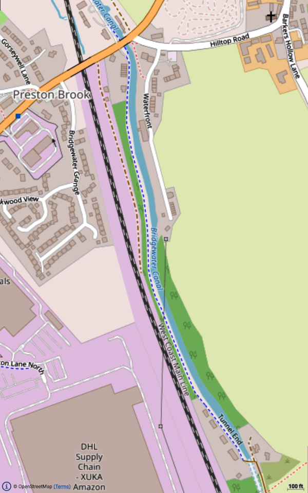
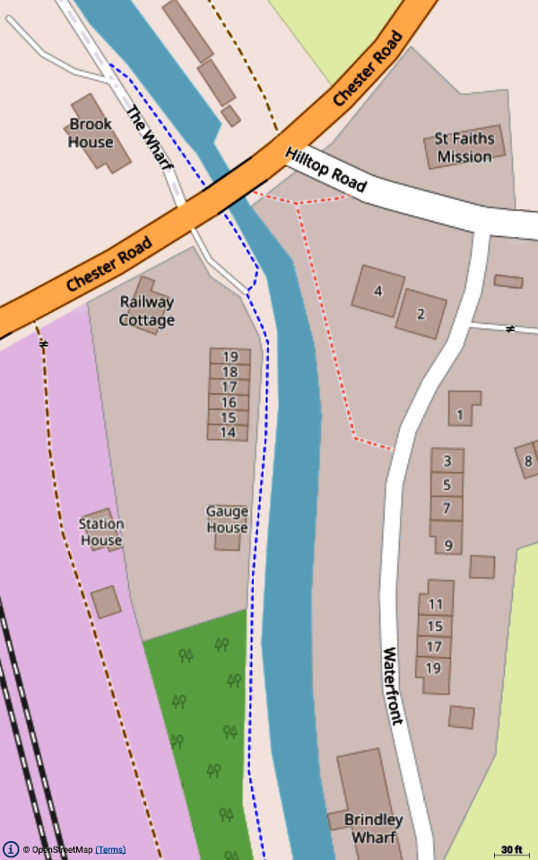
One thing that may puzzle you is why the cottages are numbered 14-19. To understand that you need to know a little of the history of the canal. By the time the Bridgewater Canal had been extended from Manchester as far as Runcorn there was already a plan to link it to the Trent and Mersey Canal through a new tunnel to be constructed some 800m south of where Preston Brook Bridge now stands. The maps below show a little of this. Incidentally, "Gauge House" and the cottages numbered 14‑19 are the seven properties that comprise the post code WA7 3AQ.
 ©
OpenStreetMap
The Bridgewater Canal from the Tunnel End to Preston Brook
Bridge.
©
OpenStreetMap
The Bridgewater Canal from the Tunnel End to Preston Brook
Bridge.
 ©
OpenStreetMap
The Preston Brook area. The cottages are the buildings
numbered 14-19.
©
OpenStreetMap
The Preston Brook area. The cottages are the buildings
numbered 14-19.
At first glance there appear to be no properties further down the tow path that have the numbers 1‑13. However, a few hundred yards further south on the opposite bank there is a terraced of cottages numbered 7‑12 and still further on, at Tunnel End, a group of cottages numbered 1‑6. (Click/tap on the "© OpenStreetMap" links on the maps above to see this for yourself.)
While you might think that it would be impossible for cottages on the other side of the canal to be part of the numbering sequence to which Canalside Cottages belong, you should be aware that when the cottages, now known as 7‑12 Cotton's Bridge, were built, there was no road on that side of the canal. The road that exists now only appears to have been constructed when the warehouse, since converted into flats and now known as Brindley Wharf, was built. Originally, the only access to the cottages was across, you've guessed it, "Cotton's Bridge" that crossed the canal at that point linking them to the tow path.
Once aware of that history then the numbering of the canal company properties at Tunnel End as 1‑6 will no longer appear to be an independent group, but rather part of the run of housing built for Bridgewater Canal staff, with numbering running from the start of the canal up to Preston Brook Bridge. It also almost certainly means that "Gauge House" is the missing number 13 in the sequence, but became known by its current name as it was the point where the "gauging" was done that set the toll for craft coming onto the Bridgewater Canal.
The Construction Date Mystery
In my early attempts to discover when the cottages were built I misunderstood how to interpret the Tithe Maps found on the Cheshire East web site. Then I found the Help Page which reveals the Tithe Commissioners did not rate the map covering Preston Brook "First Class", i.e. good enough to be used as evidence in a court. It also says:
 ©
Cheshire East Council
To get the best from the Tithe Map you need to work on the
interactive version on the council web site (click the link in the
copyright notice) as this gives you a lot more detail about each plot
marked on the map.
©
Cheshire East Council
To get the best from the Tithe Map you need to work on the
interactive version on the council web site (click the link in the
copyright notice) as this gives you a lot more detail about each plot
marked on the map.
Initially, I had assumed that the red areas were the only buildings present at the time of the survey, c1845 and a lack of plot number or any indication of a building meant that Canalside Cottages had not yet been built, especially given that the pop-up bubble reported "No information". However, it's notable that the adjacent plot #215, which includes the site of Gauge House but not Canalside Cottages is named "Dwellings and Gardens", both plural. That might suggest that the plot was intended to include both Gauge House and the cottages.
I also had in mind that when the map was drawn it was some 60 years after canal had opened, so it was not unreasonable to assume the cottages had been built by then. However, it is possible the railway was a factor. The railway had opened in 1837 and Station buildings appear, in red, on the map, but hardly likely to be dwellings, as suggested by the Commissioners guidelines. Could it be that the area south of Preston Brook Bridge had become a busy transhipment area between by then and the houses were still at the planning stage. It is also possible that the occupiers of Canalside Cottages were of such low status that they would be ineligible to pay tithes and discounted as irrelevant by those drawing up the map.
Interestingly, plot #214, which includes the terrace of six cottages at Cotton's Bridge does show the building outline and the associated record, has the title "Cottage & Gardens". This irregularity in the use of the singular and the plural strikes me as most likely caused by a somewhat casual approach to accuracy. Certainly the Cotton's Bridge cottages don't appear to be for housing a significantly different class of worker. Incidentally, both #214 and #215 have land use recorded as "Building and Garden".
In short it would appear, that canal company records need to be searched to get a better idea of when the cottages were built. Could census date provide another way of revealing when the cottages were built? I am not a subscriber to any genealogy site, so that approach is not available to me. I would welcome help from others who might have relevant information.
Modernisation
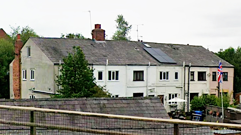
It is clear that much modernisation of the cottages has been undertaken over the years and most of what can be seen from outside will have been done in the twentieth century, starting with the installation of electricity. A recent Google Street View image also shows that one of the cottages now has solar panels installed while a number have attic rooms that wouldn't have been there from the start. All the cottages also now have a toilet and bath or shower installed. The positions of these vary, some being sited centrally alongside the staircase while others involved adding another window to the cottage.
 ©
Google
Google's Street View image of the rear of the terrace taken in July
2025. Just one cottage (17) has a single upstairs window. No.19,
hidden behind the tree, is the only other cottage to have a single
rear window upstairs.
©
Google
Google's Street View image of the rear of the terrace taken in July
2025. Just one cottage (17) has a single upstairs window. No.19,
hidden behind the tree, is the only other cottage to have a single
rear window upstairs.
It is clear that each of the cottages had its render applied independently of its neighbours as each has a slightly different texture. There are various reasons for adding a render to brickwork and it is most likely, that the first render was applied as a protection against damp or the erosion of poor quality brickwork. In the case of more recent renders it could be cosmetic as the the installation of bathroom windows would have left an odd mix of brickwork.
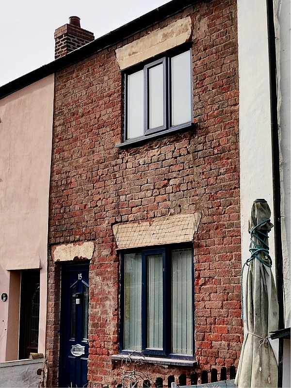 The render removed from the front of No.15.
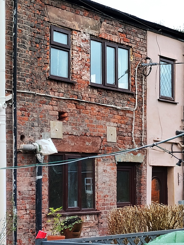 The render removed from the rear of No.15.
Recently the render was removed from No15. This reveals the pattern the bricks were laid in. It's somewhat irregular having a varying number of stretcher rows between header rows. There appear to be a variety of names for this pattern and it all depends on how many rows of stretchers there are between the header rows. The trouble is that in our terrace that number varies as you go up the wall.
In the case of this cottage it is interesting to see that where there was once a single wide window at the rear and, rather then creating the second smaller window on a blank bit of wall the original window was made smaller and a new larger one added to the wall. One can certainly see cosmetic reasons for using render on the back of the cottage, but all the others are likely to be very similar.
The Chimney Mystery
Still to be researched is why numbers 17-18 have a ridge chimney stack supporting fires in front and rear rooms when all the others have fires in the front rooms only.